Get OSM Features Within a Distance of a Point Using Python OSMnx Feature Module
Last Updated :
17 Apr, 2024
In this article, we will see how we can get open street map features within a distance of a point (latitude-longitude) using the OSMnx feature module in Python.
Syntax of osmnx.features.features_from_point() Function
The function creates a GeoDataFrame of OSM features within some distance of a point N, S, E, and W. Below is the syntax:
osmnx.features.features_from_point(center_point, tags, dist=1000)
Parameters:
- center_point (tuple) – the (lat, lon) center point around which to get the features
- tags (dict) – Dict of tags used for finding elements in the selected area.
- dist (numeric) – distance in meters
Returns: gdf
Return Type: geopandas.GeoDataFrame
OSM Features Within a Distance of Point Using OSMnx Feature Module
Below are some approaches by which we can find OSM features within a distance of point using OSMnx feature module in Python:
Find the Park Details (under Leisure) From the Open Street Map
Here, we get the park details within 1000 m of a point. In the below code, ‘leisure’ is the main tag (key) and ‘park’ is the subtag (value). The code as follows:
Python3
import osmnx as ox

# latitude-longitude point
center_point = (33.299896, -111.831638)

# osm tag
tags = {"leisure": "park"}

# retrieve feature from point
gdf = ox.features_from_point(center_point, tags, dist=1000)

# list first 5 rows from geodataframe
gdf.head(5)
Output

park details for the first 5 rows
Let’s list all the available feauters (columns) using geodataframe info() method.
Python3
Output
<class 'geopandas.geodataframe.GeoDataFrame'>
MultiIndex: 15 entries, ('way', 493099632) to ('way', 1125075333)
Data columns (total 17 columns):
 #   Column             Non-Null Count  Dtype
---  ------             --------------  -----
 0   nodes              15 non-null     object
 1   leisure            15 non-null     object
 2   name               5 non-null      object
 3   operator           2 non-null      object
 4   operator:type      2 non-null      object
 5   operator:wikidata  2 non-null      object
 6   geometry           15 non-null     geometry
 7   addr:city          2 non-null      object
 8   addr:housenumber   2 non-null      object
 9   addr:postcode      2 non-null      object
 10  addr:state         2 non-null      object
 11  addr:street        2 non-null      object
 12  description        1 non-null      object
 13  source             2 non-null      object
 14  wikidata           2 non-null      object
 15  website            1 non-null      object
 16  gnis:feature_id    1 non-null      object
dtypes: geometry(1), object(16)
memory usage: 2.9+ KB
Plotting the OSM Features Using plot_footprints() Method
In this step, we will plot the OSM features using plot_footprints() method by passing the geodataframe inside it.
Python3
fig, ax = ox.plot_footprints(gdf, figsize=(3, 3))
Output

plot showing park bounding box
We can plot it on a map by using the explore() method from geodataframe.
Python3
Output
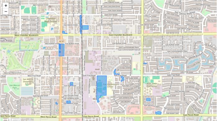
Park details
Find the Leisure Details From the Open Street Map
Apart from ‘park’ there are many other subtags under ‘leisure’ key such as swimming_area, sports_center, garden etc. To get the entire features under leisure key, we just need to mention the tag as
tags = {“leisure”: True}
Let’s look at the below code:
Python3
import osmnx as ox

center_point = (33.299896, -111.831638)
tags = {"leisure": True}

# feature from point
gdf = ox.features_from_point(center_point, tags, dist=1000)

# display it on map
gdf.explore()
Output:
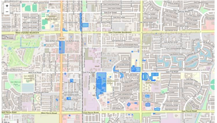
leisure details
Get Multiple Map Features from Open Street Map
Let’s try multiple tags. We can try the below tag
tags = {‘historic’:True,
‘natural’:[‘grassland’,’tree_row’],
‘landuse’:’religious’}
In the below code, it lists the entire historic details since we set ‘historic’ tag as true; In case of ‘natural’ tag, OSMnx fetches details based on ‘grassland’ and ‘tree_row’ subtags. Similary the ‘religious’ subtag details from ‘landuse’ tag.
Python3
import osmnx as ox

# latitude-longitude point
center_point = (33.299896, -111.831638)

# osm tag
tags = {'historic': True,
        'natural': ['grassland', 'tree_row'],
        'landuse': 'religious'}

# retrieve features from point
gdf = ox.features_from_point(center_point, tags, dist=1000)

# display specific columns from geodataframe
gdf[['geometry', 'name', 'historic', 'landuse', 'religion', 'natural']]
Output:
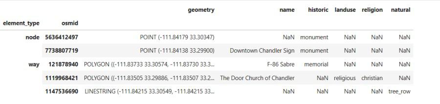
features based on multiple tags
Share your thoughts in the comments
Please Login to comment...