Get OSM Features Within a Distance of Address Using OSMnx Feature Module
Last Updated :
08 Apr, 2024
OpenStreetMap provides physical features on the ground (e.g ., roads, buildings, etc.) using tags attached to its basic data structure (nodes, ways, and relations). Each tag describes a geographic attribute of the feature for the specific node, way, or relation. In this article, we will see how we can get OSM features within a distance of address using the OSMnx feature module in Python.
Syntax of osmnx.features.features_from_address() Function
The function creates a GeoDataFrame of OSM features within some distance of the address N, S, E, W. Below is the syntax:
osmnx.features.features_from_address(address, tags, dist=1000)
Parameters:
- address (string): Address to geocode and use as the central point to get the features
- tags (dict): Dict of tags used for finding elements in the selected area. The results returned are the union of each tag. The dict keys should be OSM tags, (e.g., building, landuse, highway, etc) and the dict values should be either True to retrieve all items with the given tag, or a string to get a single tag-value combination, or a list of strings to get multiple values for the given tag.
- dist (numeric): distance in meters
Returns: gdf
Return Type: geopandas.GeoDataFrame
OSM Features Within a Distance of Address Using OSMnx Feature Module
Below are some approaches by which we can find OSM features within a distance of address using OSMnx feature module in Python:
Find the Building Details From the Open Street Map
In this step, we are finding the building details within 1000 m of a place. In the below code, we set the ‘building’ tag to true to list the available buildings within 1000m of SoHo, NewYork
Python3
import osmnx as ox

# get building details from address within 1000 m
place = "SoHo, New York, NY"
gdf = ox.features.features_from_address(
    place, {'building': True}, dist=1000)

# print first 5 building details
gdf.head(5)
Output
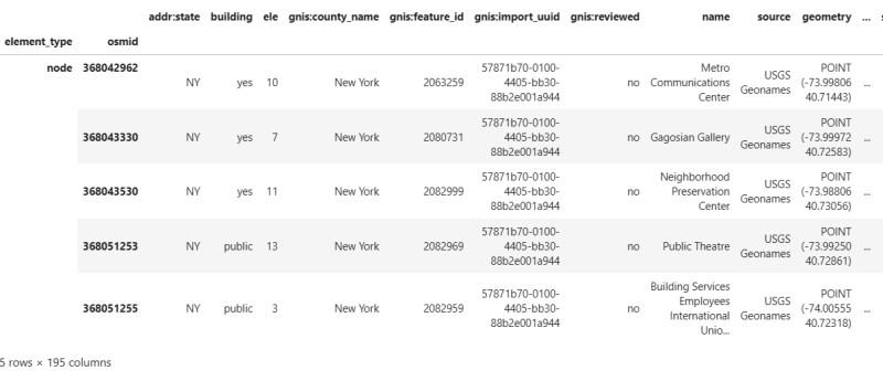
building details
We can list the available columns in our geodataframe using info() method.
Python3
Output
<class 'geopandas.geodataframe.GeoDataFrame'>
MultiIndex: 7268 entries, ('node', 4710026885) to ('relation', 1651490)
Data columns (total 99 columns):
 #   Column                   Non-Null Count  Dtype
---  ------                   --------------  -----
 0   alt_name:en              1 non-null      object
 1   alt_name:ml              2 non-null      object
 2   name                     308 non-null    object
 3   name:ml                  19 non-null     object
 4   geometry                 7268 non-null   geometry
 5   building                 7268 non-null   object
 6   addr:district            2 non-null      object
 7   addr:place               1 non-null      object
 8   addr:state               1 non-null      object
 9   amenity                  101 non-null    object
 10  denomination             2 non-null      object
 11  female                   1 non-null      object
 12  opening_hours            12 non-null     object
 13  religion                 31 non-null     object
 14  service_times            2 non-null      object
 15  wheelchair               5 non-null      object
 16  name:en                  6 non-null      object
 17  survey:date              1 non-null      object
 18  tourism                  27 non-null     object
 19  addr:city                148 non-null    object
 20  nodes                    7258 non-null   object
 21  covered                  1 non-null      object
 22  shelter_type             1 non-null      object
 23  wikidata                 3 non-null      object
 24  building:levels          81 non-null     object
 25  Administration           1 non-null      object
 26  layer                    20 non-null     object
 27  level                    1 non-null      object
 28  operator                 8 non-null      object
 29  building:part            2 non-null      object
 30  name:mr                  1 non-null      object
 31  castle_type              6 non-null      object
 32  historic                 6 non-null      object
 33  leisure                  1 non-null      object
 34  shop                     83 non-null     object
 35  source                   6035 non-null   object
 36  subdenomination          1 non-null      object
 37  payment:cash             6 non-null      object
 38  payment:credit_cards     3 non-null      object
 39  addr:postcode            51 non-null     object
 40  addr:street              145 non-null    object
 41  architect                1 non-null      object
 42  architect:wikidata       1 non-null      object
 43  architect:wikipedia      1 non-null      object
 44  brand                    26 non-null     object
 45  brand:wikidata           26 non-null     object
 46  brand:wikipedia          22 non-null     object
 47  cuisine                  7 non-null      object
 48  outdoor_seating          1 non-null      object
 49  smoking                  2 non-null      object
 50  addr:housenumber         5 non-null      object
 51  office                   35 non-null     object
 52  int_name                 1 non-null      object
 53  railway                  1 non-null      object
 54  height                   64 non-null     object
 55  internet_access          8 non-null      object
 56  internet_access:fee      3 non-null      object
 57  phone                    8 non-null      object
 58  stars                    2 non-null      object
 59  website                  6 non-null      object
 60  area                     2 non-null      object
 61  landuse                  1 non-null      object
 62  operator:wikidata        1 non-null      object
 63  atm                      4 non-null      object
 64  drive_through            2 non-null      object
 65  short_name               6 non-null      object
 66  screen                   3 non-null      object
 67  air_conditioning         2 non-null      object
 68  payment:debit_cards      1 non-null      object
 69  branch                   3 non-null      object
 70  healthcare               2 non-null      object
 71  man_made                 1 non-null      object
 72  fee                      2 non-null      object
 73  museum                   2 non-null      object
 74  name:etymology:wikidata  2 non-null      object
 75  check_date               1 non-null      object
 76  building:material        4 non-null      object
 77  description              2 non-null      object
 78  opening_hours:covid19    1 non-null      object
 79  rooms                    2 non-null      object
 80  brand:ks                 1 non-null      object
 81  brand:pa                 1 non-null      object
 82  brand:ur                 1 non-null      object
 83  name:ks                  1 non-null      object
 84  name:pa                  1 non-null      object
 85  name:ur                  1 non-null      object
 86  takeaway                 1 non-null      object
 87  alt_name                 1 non-null      object
 88  wikipedia                1 non-null      object
 89  government               2 non-null      object
 90  guest_house              1 non-null      object
 91  craft                    2 non-null      object
 92  clothes                  1 non-null      object
 93  healthcare:speciality    1 non-null      object
 94  operator:type            1 non-null      object
 95  ref                      1 non-null      object
 96  repair                   1 non-null      object
 97  ways                     1 non-null      object
 98  type                     1 non-null      object
dtypes: geometry(1), object(98)
memory usage: 5.8+ MB
Plotting the OSM Features Using plot_footprints() Method
In this step, we will plot the OSM features using plot_footprints() method by passing the geodataframe inside it.
Python3
fig, ax = ox.plot_footprints(gdf, figsize=(3, 3))
Output
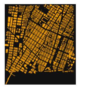
building plot
We can plot it on a map by using the explore() method from geodataframe.
Python3
Output
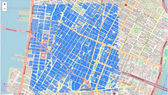
building feature on map
Find the Emergency Support System Details from the Open Street Map
We can find the emergency support system details like hospitals, ambulances, etc. by setting the ’emergency’ tag as true and OSMnx will lists all the available emergency support system.
Python3
import osmnx as ox

place = "Thiruvananthapuram, Kerala"
gdf = ox.features.features_from_address(
    place, {'emergency': True}, dist=3000)
print(gdf)
Output
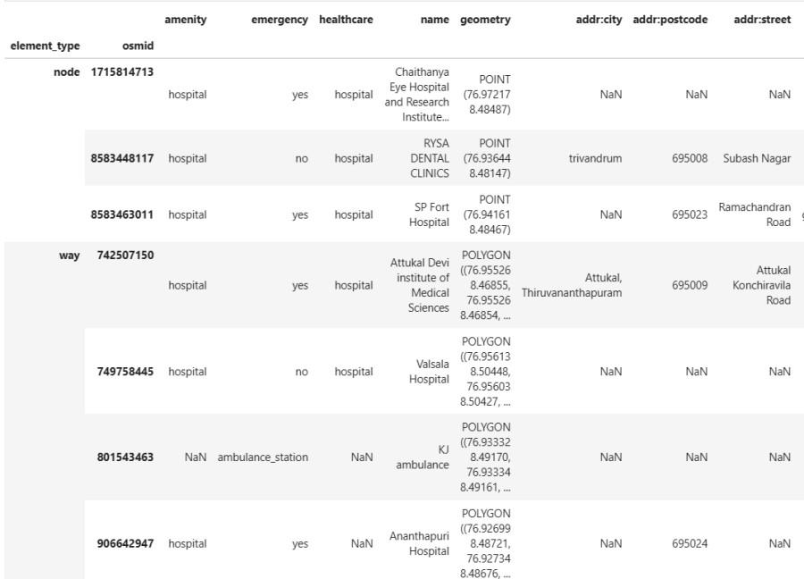
emergency as tag
Get Multiple Map Features from Open Street Map
Let’s try multiple tags. We can try the below tag
tags = {‘amenity’:True,
‘landuse’:[‘retail’,’commercial’],
‘highway’:’bus_stop’}
In the below code, it lists the entire amenity available since we set ‘amenity’ tag as true; In case of ‘landuse’ tag, OSMnx fetches details based on ‘retail’ and ‘commercial’ subtags. Similary the ‘bus_stop’ subtag details from ‘highway’ tag.
Python3
import osmnx as ox

tags = {'amenity': True,
        'landuse': ['retail', 'commercial'],
        'highway': 'bus_stop'}
# fetch multiple features
gdf = ox.features.features_from_address(
    "Thiruvananthapuram, Kerala", tags, dist=500)
# display it on map
gdf.explore()
Output
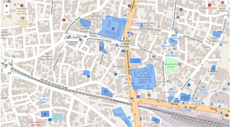
Multiple Features
Share your thoughts in the comments
Please Login to comment...