Class 11 Geography Sensor Resolutions Notes: In Class 11 Geography Chapter 6, we learn about sensor resolutions, which are important for understanding how remote sensing works. Sensor resolution refers to the level of detail captured by remote sensing devices. There are two main types: spatial resolution and spectral resolution. Spatial resolution tells us how clear the images are, while spectral resolution tells us how well the sensors can detect different colors or wavelengths of light. By understanding sensor resolutions, we can better analyze remote sensing data to learn about things like land cover, vegetation health, and environmental changes.
Our Geography Notes Class 11 is a valuable resource to enhance your problem-solving skills and prepare for your Social Science Class 11 exams. By utilizing our comprehensive notes, you can develop a strong foundation in Geography and improve your problem-solving skills.
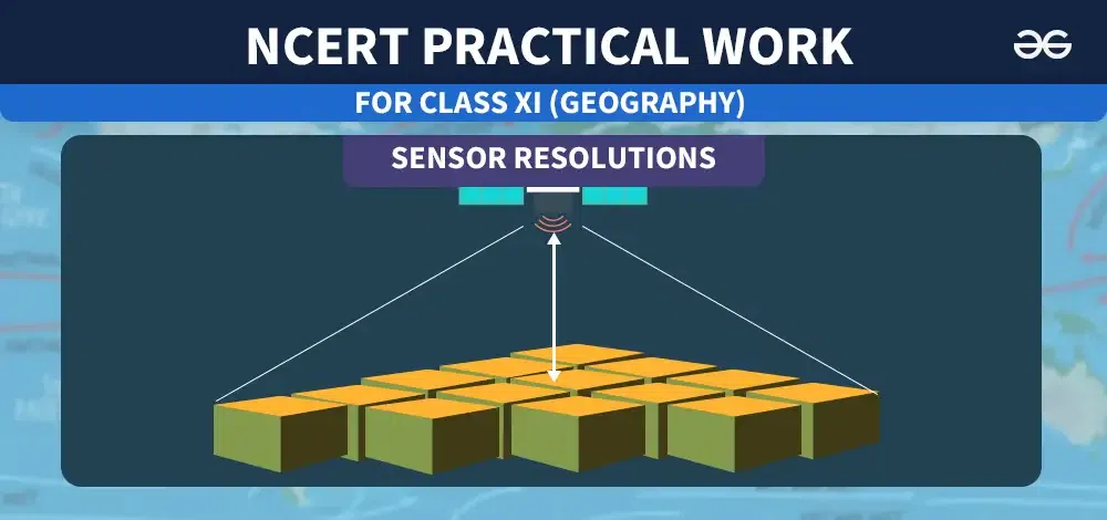
Sensor Resolutions| Class 11 Geography Notes
What are Sensor Resolutions?
Remote sensors are characterized by spatial, spectral, and radiometric resolutions. These resolutions are essential for extracting valuable information related to various terrain conditions.
Spatial Resolution
Spatial resolution refers to how clear the features on the Earth’s surface appear in an image. It’s all about a sensor’s ability to distinguish between different objects and features on the Earth’s surface. In simpler terms, spatial resolution is the ratio between the size of a pixel and the area it represents.
The clarity of features in an image depends on the size of the pixel and the number of pixels in the image. Each pixel can only represent one color, so if a pixel covers a large area of land, it might hide smaller details within that area.
For example, imagine a square kilometer area with forests, urban areas, water bodies, and other uses. If one pixel represents one square kilometer, the image will likely show only the forest area because it’s the largest. It won’t differentiate between urban areas, water bodies, and other uses within that square kilometer.
But if the pixel size is smaller, say 250 square meters, there will be 16 smaller pixels in the image, providing a more detailed picture of the land use. Increasing the number of pixels and decreasing their size improves spatial resolution.
Different purposes require different spatial resolutions. Climatologists studying global warming might need 2-5 kilometers of spatial resolution, while defense establishments might require 1-meter resolution for public safety purposes.
Spectral Resolution
The amount of detail captured in satellite imagery depends on how many wavelengths the sensor can detect. If a sensor can detect more wavelengths across the electromagnetic spectrum, it will capture more information about land use and land cover.
For instance, if we only use the visible spectrum, we’ll only see features that are visible to the human eye, like iron ore in soil. But we won’t be able to detect other important minerals. However, using the gamma ray spectrum, we can locate potassium, uranium, and thorium. Similarly, the infrared spectrum is useful for studying heat signatures of objects.
In simple terms, the more spectrums a satellite imagery includes, the higher its spectral resolution. There are three types of imagery in remote sensing based on spectral resolution: mono-spectral, multi-spectral, and hyper-spectral imagery.
Radiometric Resolution
Radiometric resolution refers to a sensor’s ability to detect subtle differences in the radiated energy from the Earth’s surface.
In simpler terms, it’s the number of shades of gray that a pixel can have in a satellite image. This is measured in bits, with satellite images available in 1-bit, 2-bit, 4-bit, 8-bit, and so on.
For example, a 1-bit image means there are only two colors available: black and white. Similarly, a 4-bit image can have 16 different shades of gray in each pixel. An 8-bit image means there are 256 digital values or shades available.
So, if we’re using a specific spectrum band, like near-infrared, a sensor with 8-bit resolution can capture 256 different types of energy in that band.
Conclusion
Sensor resolutions are important in remote sensing because they decide how clear and detailed the information gathered from Earth’s surface will be. Spatial resolution affects how well objects can be seen, spectral resolution determines what types of wavelengths are detected, and radiometric resolution influences the ability to spot differences in energy levels.
Knowing about these resolutions is crucial for accurately interpreting satellite images and getting useful information for tasks like planning land use and monitoring the environment. By understanding and adjusting sensor resolutions, scientists and analysts can make remote sensing more effective in solving real-world problems and guiding decision-making.
1. CBSE Notes Class 10 Geography Chapter 4 – Agriculture
2. CBSE Class 10 Geography Notes Chapter 3 : Water Resources
3. CBSE Notes Class 10 Geography Chapter 5: Minerals and Energy Resources
4. CBSE Notes Class 10 Geography Chapter 7- Lifelines of National Economy
FAQs on Class 11 Geography Sensor Resolutions
What are sensor resolutions in remote sensing?
Sensor resolutions in remote sensing refer to the ability of sensors to capture and distinguish different aspects of Earth’s surface, including spatial, spectral, and radiometric features.
Why are sensor resolutions important in remote sensing?
Sensor resolutions are crucial because they determine the level of detail and accuracy in the information collected from Earth’s surface. Higher resolutions enable better interpretation and analysis of satellite imagery.
What is spatial resolution?
Spatial resolution refers to the clarity and level of detail in satellite images. It determines the ability of sensors to distinguish between different objects and features on Earth’s surface.
What is spectral resolution?
Spectral resolution refers to the ability of sensors to detect and differentiate between different wavelengths of electromagnetic radiation. It determines the range of information captured in satellite imagery.
What is radiometric resolution?
Radiometric resolution refers to the sensitivity of sensors in detecting variations in the intensity of electromagnetic radiation. It determines the number of shades or levels of brightness captured in satellite images.
Share your thoughts in the comments
Please Login to comment...