Class 11 Geography Stages of Remote Sensing Notes: The notes on the stages of remote sensing are important for CBSE Class 11 Geography students. Understanding the process of remote sensing is essential for comprehending how data is collected, processed, and utilized in geographic studies.
By learning about these stages, students can grasp the fundamental concepts of remote sensing and its applications in various fields such as environmental monitoring, urban planning, agriculture, and disaster management.
Stages of Remote Sensing| Class 11 Geography Notes
What is Remote Sensing?
The concept of remote sensing emerged in the early 1960s. It refers to the comprehensive processes employed to collect and measure information about various properties of objects and phenomena using a recording device called a sensor.
What distinguishes remote sensing is that the sensor does not make physical contact with the objects or phenomena being studied. Essentially, remote sensing involves the interaction between the surface of an object, the sensor, and energy waves carrying the information being collected.
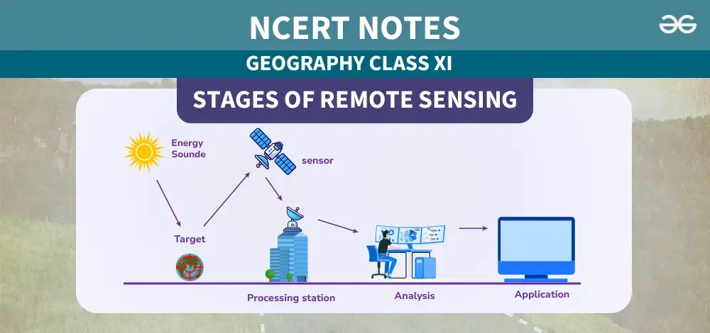
Stages of Remote Sensing
The processes used in remote sensing data acquisition involve several basic steps to collect information about the properties of objects and phenomena on the Earth’s surface. These steps are as follows:
- Source of Energy (sun/self-emission)
- Transmission of energy from the source to the Earth’s surface
- Interaction of energy with the Earth’s surface
- Propagation of reflected/emitted energy through the atmosphere
- Detection of the reflected/emitted energy by the sensor
- Conversion of received energy into photographic/digital data
- Extraction of information from the data products
- Conversion of information into map/tabular formats.
Source of Energy (sun/self-emission)
Sun is the primary source of energy used in remote sensing. Artificial sources like flashguns or energy beams from radar are also utilized to gather information about objects and phenomena.
Transmission of Energy from the Source to the Surface of the Earth
Energy emitted from a source travels to the object’s surface as waves of energy at the speed of light, constituting Electromagnetic Radiation (EMR). These energy waves vary in size and frequency, which are plotted on the Electromagnetic Spectrum.
The spectrum categorizes energy waves into Gamma, X-rays, Ultraviolet rays, Visible rays, Infrared rays, Microwaves, and Radio waves based on their size and frequency. Different applications utilize different regions of this spectrum, with remote sensing primarily utilizing the visible, infrared, and microwave regions of energy.
Interaction of energy with the Earth’s surface
Once the energy reaches the surface of the Earth, it interacts with various objects. This interaction can result in absorption, transmission, reflection, or emission of energy from the objects. Objects differ in composition, appearance, and other properties, causing their responses to energy to vary. The same object may respond differently to energy across different regions of the spectrum.
For instance, a freshwater body absorbs more energy in the red and infrared regions of the spectrum, appearing dark or black in satellite images. In contrast, turbid water bodies reflect more energy in the blue and green regions of the spectrum, appearing lighter in tone.
Propagation of reflected/emitted energy through the atmosphere
When energy is reflected from the Earth’s surface objects, it returns to the atmosphere. The atmosphere consists of gases, water molecules, and dust particles. The reflected energy interacts with these atmospheric components, altering its properties.
For example, carbon dioxide (CO2), hydrogen (H), and water molecules absorb energy in the middle infrared region, while dust particles scatter blue energy. As a result, the energy absorbed or scattered by atmospheric constituents does not reach the sensors onboard satellites, and the properties of the objects carried by such energy waves remain unrecorded.
Detection of the reflected/emitted energy by the sensor
The sensors recording the received energy are positioned in near-polar sun-synchronous orbits at altitudes ranging from 700 to 900 km. These satellites are designated as remote sensing satellites, such as the Indian Remote Sensing Series. In contrast, weather monitoring and telecommunication satellites occupy geostationary positions, meaning they are constantly positioned over their orbits, synchronizing with the Earth’s rotation.
They orbit the Earth at an altitude of approximately 36,000 km, as seen with satellites like the INSAT series. A comparison between remote sensing and weather monitoring satellites is provided in Box (6.1). Figure 6.6 depicts the orbits of Sun Synchronous and Geostationary satellites, respectively.
Conversion of Energy Received into Photographic/ Digital Form of Data
The digital image consists of digital numbers organized in rows and columns. These numbers can also be transformed into an analog (picture) format of data. The sensor onboard a satellite orbiting the Earth electronically transmits the captured image data to an Earth Receiving Station located in various parts of the world. In India, one such station is situated at Shadnagar near Hyderabad.
Extraction of Information Contents from Data Products
Once the image data reaches the earth station, it undergoes processing to correct errors that may have occurred during the collection of image data. Once corrected, information extraction is performed from digital images using digital image processing techniques and from analog data products using visual interpretation methods.
Conversion of Information into Map/Tabular Forms
The interpreted information is then delineated and converted into various layers of thematic maps. Quantitative measures are taken to generate tabular data.
Conclusion
The stages of remote sensing involve several steps to gather, process, and understand information about the Earth’s surface. From capturing energy to creating useful maps and tables, each stage helps us learn more about our planet and make better decisions about things like farming, city planning, and protecting the environment.
Remote sensing is important because it gives us valuable insights that help us take care of our world.
Related Links
- CBSE Class 8 Geography Chapter-Wise Revision Notes
- CBSE Class 10 Geography Notes
- CBSE Class 9 Geography Revision Notes
- CBSE Notes Class 10 Geography Chapter 1- Resources and Development
FAQs on Class 11 Geography Stages of Remote Sensing
What are the main stages of remote sensing?
The main stages of remote sensing include energy source, transmission of energy, interaction with Earth’s surface, propagation through the atmosphere, detection by sensors, data conversion, information extraction, and map/tabular representation.
How does remote sensing help in gathering information about the Earth’s surface?
Remote sensing uses sensors to collect data about the Earth’s surface without direct physical contact. This data helps in studying various features such as land use, vegetation, water bodies, and geological formations.
Can you explain the process of data transmission in remote sensing?
Data collected by sensors is transmitted to Earth receiving stations, where it is processed to eliminate errors. After correction, the data is used for information extraction.
How are the collected images processed for error elimination?
Collected images undergo processing to eliminate errors caused during data collection. This correction ensures the accuracy of the data before further analysis.
What techniques are used for information extraction from digital images?
Digital image processing techniques are used to extract information from images. These techniques include filtering, enhancement, and classification to identify and analyze specific features.
Share your thoughts in the comments
Please Login to comment...