Northern & North-Eastern Mountains| Class 11 Geography Notes
Last Updated :
01 May, 2024
Class 11 Geography Northern & North-Eastern Mountains notes are helpful resources for students because they explain mountain ranges in easy terms. In this article, we also discuss mountains like the Himalayas and other ranges in the north and northeast of India. By reading these notes, students can understand more about the geography of these regions and how mountains play an important role in them.
The Northern & North-Eastern Mountains notes cover all the necessary topics that are extremely important for the examination 2024. It can save you time and will positively affect your results.
Northern & North-Eastern Mountains| Class 11 Geography Notes
North and Northeastern Mountains
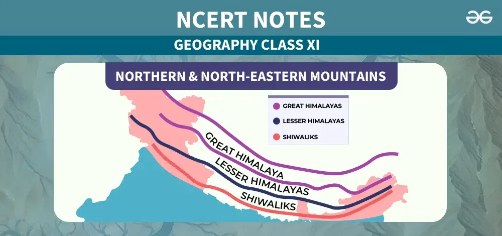
- The North and Eastern Mountains include the Himalayas and the Northeastern highlands.
- Himalayas consist of parallel mountain ranges such as the Greater Himalayan range, the Middle Himalayas, and the Shiwalik.
- The orientation of these mountains is typically northwest to southeast, but it varies in different regions.
- In Darjeeling and Sikkim, the Himalayas run east-west, while in Arunachal Pradesh, they run southwest-northwest.
- In Nagaland, Manipur, and Mizoram, they run north-south.
- The Great Himalayan Range, also known as the Central Axial Range, extends around 2,500 kilometers from east to west.
- The breadth of the Himalayas ranges from 160 to 400 kilometers from north to south.
- These mountains are predominantly composed of sandstones and are covered with lush vegetation.
- The Purvanchal hills, located to the west, have a convex shape.
- The Brahmaputra river marks the eastern boundary of the Himalayas, curving southward beyond the Dihang canyon from the eastern highlands of Purvanchal.
Northern Mountains
The Himalayan Mountains form India’s northern mountain range and are renowned as the world’s tallest mountain ranges.
Trans Himalayas
- The Trans Himalayas are situated immediately north of the Great Himalayan Range, often referred to as the Tibetan Himalaya due to their extensive presence in Tibet.
- The Zaskar Range hosts significant peaks like Nanga Parbat (8126 m), located within the Trans Himalayas.
- North of the Zaskar Range lies the Ladakh Range, running parallel to it and featuring peaks exceeding 6000 meters in elevation.
- The Kailas Range, a branch of the Ladakh Range in western Tibet, includes Mount Kailash (6714 m), the highest point in the area and the source of the Indus River.
- The Great Karakoram Range, also known as the Krishnagiri Range, extends around 800 kilometers east of the Pamir, forming India’s northernmost Trans-Himalayan Range.
Greater Himalayas
- The Greater Himalayas, also known as the Inner Himalaya, Central Himalaya, and Himadri, constitute the same mountain range characterized by an average elevation of 6100 meters above sea level and a breadth of around 25 kilometers.
- It is mostly of core crystallines such as granites and gneisses with metamorphosed sediments on top, this range features folds that are asymmetrical, creating a steep south slope and a gentle north slope, giving rise to hog back topography.
- Convexing towards the south, the Greater Himalayas terminate abruptly at the syntaxial bends, one located in the northwestern Nanga Parbat and the other in the northeastern Namcha Barwa.
- This mountain range is home to some of the world’s highest peaks, many of which remain perpetually snow-covered.
Middle Himalayas
- Positioned between the Shiwaliks to the south and the Greater Himalayas to the north, the Middle Himalayas run nearly parallel to both ranges.
- Also referred to as the Himachal Pradesh or the Lower Himalaya, these mountains stretch approximately 2400 kilometers long and are 60-80 kilometers broad.
- The elevation of the Lower Himalayas ranges between 3500 and 4500 meters above sea level, with many peaks surpassing 5050 meters and remaining snow-covered throughout the year.
- The southern slopes of the Lower Himalayas are steep and barren, while the northern slopes are gentle and forested, characterized by the Mussoorie and Nag Tibba hills in Uttarakhand.
Outer Himalayas – Shivalik Range
- The Outer Himalayas, also known as the Shivalik range, lie between the Great Plains and the Lesser Himalayas, with elevations ranging from 600 to 1500 meters.
- Stretching approximately 2400 kilometers from the Potwar Plateau to the Brahmaputra Valley, these hills feature gentle northern slopes and steep southern slopes.
- The Shivalik range varies in breadth, ranging from 50 kilometers in Himachal Pradesh to less than 15 kilometers in Arunachal Pradesh.
- Covered in lush forests from North-East India to Nepal, the forest cover decreases as one moves west from Nepal, especially in Punjab and Himachal Pradesh, where the southern slopes are almost devoid of forest cover.
- Chos, which are seasonal streams, criss-cross these mountains, with hills forming part of anticlines or synclines, and valleys part of synclines.
Punjab Himalayas
- The Punjab Himalayas are mainly shared by Jammu and Kashmir and Himachal Pradesh, often referred to as the Kashmir and Himachal Himalayas.
- Major ranges in the Punjab Himalayas include the Karakoram, Ladakh, Pir Panjal, Zaskar, and Dhaola Dhar, with the overall elevation decreasing towards the west.
- Notable formations in the Kashmir Himalayas are the Karewas, which are lake deposits found on flat-topped terraces in the Kashmir valley and on the sides of the Pir Panjal mountain. These deposits consist of clays, silts, and sands and show signs of glaciation.
- The presence of tilted Karewas beds on the Pir Panjal’s flanks suggests recent uplifting of the Himalayas, with Karewas being known for the production of Zafran, a local type of saffron.
North-Eastern Mountains
- The Brahmaputra River marks the eastern boundary of the Himalayas, with the Eastern highlands, or Purvanchal, curving steeply southward beyond the Dihang canyon.
- Part of the Himalayan mountain chain, the North-Eastern Hills & Mountains have a north to south alignment and are known by various local names, including Patkai Bum in the north, Naga hills in the south, and Manipur hills in the north.
- These low hills are inhabited by diverse tribes practicing Jhum agriculture, and the region is geologically unstable, characterized by multiple faults.
- The north–south hill ranges are formed by small parallel valleys sloping westward, with Mount Dapha in Arunachal Pradesh being the tallest mountain in the area at 15,020 feet (4,578 meters).
- Prominent rivers in the region include Lohit, Burhi Dihing, Diyung, Kusiyara, Gumti, Kaladan, Manipur, Tixu, Nantaleik, and Naurya.
Important Hills and Mountains
|
Hills and Mountains
|
Location
|
Significance
|
|
Patkai Bum hills
|
Nagaland
|
- The Pat-kai are a group of mountains on the Indo-Myanmar border that lie in the north-eastern Indian states of Arunachal Pradesh, Nagaland, and Myanmar’s Upper Burma area.
- Feature unique geographical formations with conical summits, steep slopes, and deep valleys.
|
|
Khasi Hills
|
Meghalaya
|
- Form an integral part of the Garo-Khasi-Jaintia range, contributing to the biodiversity of the region.
- Act as a watershed, receiving water from Brahmaputra and Surma river tributaries.
|
|
Garo Hills
|
Meghalaya
|
- Provide habitat to diverse flora and fauna, contributing to the ecological balance of the region.
- Attract tourists due to their scenic beauty and the presence of Nokrek National Park, which conserves a variety of plant and animal species.
|
|
Jaintia Hills
|
Meghalaya
|
- Support timber production and contribute to the livelihoods of local communities.
- The Kopili River, with its rocky terrain and waterfalls, adds to the natural beauty and potential tourism attractions.
|
|
Naga Hills
|
Nagaland
|
- Act as a natural barrier between India and Myanmar, influencing the region’s geopolitical landscape.
- Provide opportunities for mountaineering and adventure tourism, particularly around Mount Saramati.
|
|
Mizo Hills (Lushai Hills)
|
Manipur
|
- Provide an essential habitat for indigenous communities and biodiversity.
- Agriculture and horticulture are practised in the intermountain valleys.
|
|
Barail Range
|
Assam
|
- Support various ecosystems, including forests, rivers, and valleys, contributing to regional biodiversity.
- Provide resources for local communities, including timber and non-timber forest products.
|
|
Dafla Hills
|
Arunachal Pradesh
|
- The homeland of the Daphla tribe, preserving their cultural heritage.
- Contribute to the natural beauty and ecological diversity of the region.
|
|
Mishmi Hills
|
Arunachal Pradesh
|
- Provide habitat to diverse flora and fauna, including rare and endemic species.
- Contribute to the region’s biodiversity and ecosystem services, such as water regulation and soil conservation.
|
Significance North and Northeastern Mountains
- The Himalayas play a crucial role in intercepting the effects of climate change on the summer monsoon due to their high height, vast sprawl, and expansive coverage.
- They act as a barrier, preventing the intrusion of chilly Siberian air masses into India, thus influencing the country’s overall climate patterns.
- The Himalayan region is rich in mineral resources, including gold, silver, copper, lead, and more. In Kashmir, coal deposits are also found.
- However, the extraction of these minerals is challenging due to the rugged terrain and the current limitations in technological capabilities, making it economically unfeasible.
- Apart from their geological significance, the North and Northeastern Mountains hold strategic importance for defense purposes, as well as for their contribution to perennial river systems, fertile soils, diverse forest wealth, flourishing orchards, and various other mineral resources.
Conclusion
The mountains in the northern and north-eastern regions of India, like the Himalayas and those in the northeast, are very important. These mountains are not only beautiful but also give us water, diverse wildlife, and spiritual inspiration. It’s important to take care of them to keep everything in balance and to make sure people and nature thrive.
Different sections of the Himalayas have distinct native names. In the north, they are called Patkai Bum, Naga hills, and Manipur hills, while in the south, they are known as Mizo or Lushai hills.
Related Links
- CBSE Notes Class 10 Geography Chapter 1- Resources and Development
- Branches of Geography Class 11 Notes
- Notes Chapter 1: Geography as a Discipline
- CBSE Notes Class 10 Geography Chapter 4 – Agriculture
Class 11 Geography Northern & North-Eastern Mountains- FAQs
What are the major mountain ranges in the northern and north-eastern regions of India?
The major mountain ranges include the Himalayas, Patkai Bum, Naga Hills, Manipur Hills, Mizo Hills (Lushai Hills), and others.
What is the significance of the Himalayas?
The Himalayas are the world’s tallest mountain ranges and play a crucial role in shaping the climate, geography, and culture of the region.
How do the mountains in the north-eastern region contribute to the environment?
The mountains in the north-eastern region provide habitat to diverse wildlife, act as a source of rivers, and influence the climate of the region.
What are some of the native names given to different sections of the Himalayan mountains?
In the north, they are known as Patkai Bum, Naga hills, and Manipur hills, while in the south, they are known as Mizo or Lushai hills.
Share your thoughts in the comments
Please Login to comment...