Gps Tracker Using Python
Last Updated :
05 Feb, 2024
A GPS tracker is a device designed to calculate precise and accurate locations generally by receiving data from satellite sources and computing the exact coordinates of the desired location. To achieve this, we will utilize the requests library in Python, along with some other necessary libraries. We are also going to use folium, a Python library help us build the map that we are going to display at the end to the user.
This article covers all the steps with some necessary requirements on how we can make a GPS tracker in Python with ease. We will cover all the basic steps with clear and concise explanations.
GPS Tracker Using Python
Below is the step-by-step procedure by which we can track the user location using its IP address in Python:
Step 1: Install Necessary Libraries/Packages
In this step, we will install all the necessary packages or libraries required to create a GPS tracker in Python.
pip install folium
pip install requests
pip install selenium
pip install datetime
Step 2: Import Libraries
In this step, we will import all necessary libraries that are required in this project.
Python3
import requests
from selenium import webdriver
import folium
import datetime
import time
|
Step 3: Creating a method to get the user coordinates.
In this step, we will be creating a user defined function to the user coordinates ( i.e. longitude and latitude). We are requesting for users Ip address info. This will return us a json file. Through this json file, we will extract user latitude, longitude, city and state.
Python3
def locationCoordinates():
try:
data = response.json()
loc = data['loc'].split(',')
lat, long = float(loc[0]), float(loc[1])
city = data.get('city', 'Unknown')
state = data.get('region', 'Unknown')
return lat, long, city, state
except:
print("Internet Not avialable")
exit()
return False
|
Step 4: Creating the object of the necessary library
In this step we will define a method “gps_locator()” with no parameter. Then, we will create a folium map object under our created method.
Python3
def gps_locator():
obj = folium.Map(location=[0, 0], zoom_start=2)
|
Step 5: Fetching Coordinates, City and State and Map Generation
In this step, we will fetch coordinates from our created method i.e. locationCoordinates(). From this coordinates, we will generate a map pointing to our exact location with the help of folium library. We will consider doing all this work under try block to avoid any undesirable errors.
Python3
try:
lat,long,city,state = locationCoordinates()
print("You Are in {},{}".format(city,state))
print("Your latitude = {} and longitude = {}".format(lat,long))
folium.Marker([lat,long], popup='Current Location').add_to(obj)
fileName = "C:/screengfg/Location" + str(datetime.date.today()) + ".html"
obj.save(fileName)
return fileName
except:
print("Internet Not avialable")
exit()
return False
|
Step 6: Creation of main method and displaying the map.
In this method, we will create a a main method. Under this main method, we will call gps_locator() method. This method will return a file location. Through this file location, we will open that in our chrome browser using selenium. We are also closing our browser with 30 seconds, in case user do not close it manually.
Python3
if __name__ == "__main__":
print("---------------GPS Using Python---------------\n")
page = gps_locator()
print("\nOpening File.............")
dr = webdriver.Chrome()
dr.get(page)
time.sleep(30)
dr.quit()
print("\nBrowser Closed..............")
|
Complete Code Implementation
Here we have provided you the compiled code with necessary instruction in form of comments.
Python3
import requests
from selenium import webdriver
import folium
import datetime
import time
def locationCoordinates():
try:
data = response.json()
loc = data['loc'].split(',')
lat, long = float(loc[0]), float(loc[1])
city = data.get('city', 'Unknown')
state = data.get('region', 'Unknown')
return lat, long, city, state
except:
print("Internet Not avialable")
exit()
return False
def gps_locator():
obj = folium.Map(location=[0, 0], zoom_start=2)
try:
lat, long, city, state = locationCoordinates()
print("You Are in {},{}".format(city, state))
print("Your latitude = {} and longitude = {}".format(lat, long))
folium.Marker([lat, long], popup='Current Location').add_to(obj)
fileName = "C:/screengfg/Location" + \
str(datetime.date.today()) + ".html"
obj.save(fileName)
return fileName
except:
return False
if __name__ == "__main__":
print("---------------GPS Using Python---------------\n")
page = gps_locator()
print("\nOpening File.............")
dr = webdriver.Chrome()
dr.get(page)
time.sleep(4)
dr.quit()
print("\nBrowser Closed..............")
|
Output
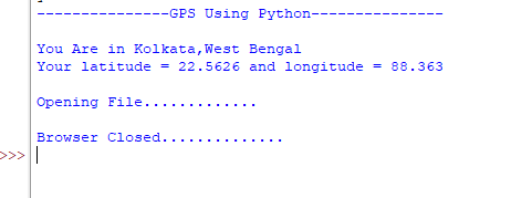
Console Output
We can clearly see, its displaying city with the state.
Video Output
Conclusion
A GPS tracker is device is designed to calculate and display precise location generally received from satellite sources. We have made a GPS tracker in Python through fetching information from user’s ip address. We have use an API to fetch details and then calculates the exact coordinates. From this coordinates, we have get our current address and also we have created a html file of the map and displayed it in our browser with the help of selenium. It is simple to understand and it also uses some different and libraries to achieve the end task.
Share your thoughts in the comments
Please Login to comment...