Agro Climatic Zones in India
Last Updated :
28 Mar, 2024
Agro Climatic Zones in India: For the development of resources, the country has been divided into fifteen agricultural regions which are based on agro-climatic features, which include soil type, climate which includes temperature as well as rainfall, and also variations based on the available water resources. It is an extension of the climate classifications while keeping in mind the sustainability of agriculture.
In this article, we will learn about various agro-climatic zones in India!
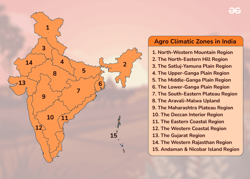
Agro Climatic Zones in India
What are the Agro Climatic Zones of India?
The geographical area of India is divided into 15 agro-climatic regions. These are further divided into more homogeneous 72 sub-zones. The 15 agro-climatic zones are:
|
Zone
|
Name of the Zone
|
States Covered
|
|
Zone 1
|
Western Himalayan Region
|
Jammu and Kashmir, Uttar Pradesh
|
|
Zone 2
|
Eastern Himalayan Region
|
Assam, Sikkim, West Bengal and all other North-Eastern states
|
|
Zone 3
|
Lower Gangetic Plains Region
|
West Bengal
|
|
Zone 4
|
Middle Gangetic Plains Region
|
Uttar Pradesh, Bihar
|
|
Zone 5
|
Upper Gangetic Plains Region
|
Uttar Pradesh
|
|
Zone 6
|
Trans-Gangetic Plains Region
|
Punjab, Haryana, Delhi and Rajasthan
|
|
Zone 7
|
Eastern Plateau and Hills Region
|
Maharashtra, Uttar Pradesh, Orissa and West Bengal
|
|
Zone 8
|
Central Plateau and Hills Region
|
MP, Rajasthan, Uttar Pradesh
|
|
Zone 9
|
Western Plateau and Hills Region
|
Maharashtra, Madhya Pradesh and Rajasthan
|
|
Zone 10
|
Southern Plateau and Hills Region
|
Andhra Pradesh, Karnataka, Tamil Nadu
|
|
Zone 11
|
East Coast Plains and Hills Region
|
Orissa, Andhra Pradesh, Tamil Nadu and Pondicherry
|
|
Zone 12
|
West Coast Plains and Ghat Region
|
Tamil Nadu, Kerala, Goa, Karnataka, Maharashtra
|
|
Zone 13
|
Gujarat Plains and Hills Region
|
Gujarat
|
|
Zone 14
|
Western Dry Region
|
Rajasthan
|
|
Zone 15
|
The Islands Region
|
Andaman and Nicobar, Lakshadweep
|
Primary Objectives of Agro Climatic Zone Classification
The classification of agro-climatic zones serves multiple crucial purposes:
- Optimization of Agricultural Practices: By categorizing regions based on their climatic characteristics, it becomes easier to tailor agricultural practices to suit local conditions, thereby maximizing yields and minimizing risks.
- Resource Allocation: Governments and agricultural organizations utilize agro-climatic zoning to allocate resources such as subsidies, infrastructure, and research funding in a targeted manner, ensuring efficient utilization.
- Crop Diversification: Understanding the climatic nuances of different regions facilitates crop diversification, reducing dependence on a single crop and enhancing resilience against adverse weather events or market fluctuations.
- Policy Formulation: Agro-climatic zoning serves as a foundation for formulating agricultural policies, including land use planning, water resource management, and disaster preparedness, fostering sustainable development.
What are the Climatic Zones?
The geographical area of India has been divided into 15 agro climatic regions and these have been further divided into 72 sub-zones. The 15 agro-climatic zones are as follows:
- Western Himalayan Region: Covers the states of Jammu and Kashmir, Himachal Pradesh, and Uttarakhand. Known for temperate climate and cultivation of fruits like apples and cherries.
- Eastern Himalayan Region: Includes the northeastern states of Arunachal Pradesh, Assam, Meghalaya, Manipur, Mizoram, Nagaland, Sikkim, and Tripura. Known for tea cultivation, horticulture, and rice farming.
- Lower Gangetic Plain Region: Encompasses parts of Bihar, West Bengal, and Uttar Pradesh. Suitable for rice, wheat, sugarcane, and jute cultivation.
- Middle Gangetic Plain Region: Covers parts of Uttar Pradesh and Bihar. Suitable for rice, wheat, and pulses cultivation.
- Upper Gangetic Plain Region: Includes parts of Uttar Pradesh and Bihar. Suitable for wheat, sugarcane, and pulses cultivation.
- Trans-Gangetic Plains Region: Spans across parts of Uttar Pradesh, Bihar, Punjab, Haryana, and Delhi. Known for wheat, rice, and sugarcane cultivation.
- Eastern Plateau and Hills Region: Covers states like Jharkhand, Chhattisgarh, Odisha, and parts of West Bengal. Suitable for rice, pulses, and oilseed cultivation.
- Central Plateau and Hills Region: Encompasses parts of Madhya Pradesh, Maharashtra, and Gujarat. Suitable for cotton, oilseeds, pulses, and millets cultivation.
- Western Plateau and Hills Region: Includes parts of Maharashtra, Gujarat, Rajasthan, and Goa. Suitable for millets, pulses, oilseeds, and cotton cultivation.
- Southern Plateau and Hills Region: Covers parts of Karnataka, Tamil Nadu, Kerala, and Andhra Pradesh. Suitable for coffee, tea, spices, and plantation crops.
- East Coast Plains and Hills Region: Encompasses parts of Andhra Pradesh, Tamil Nadu, Odisha, and West Bengal. Suitable for rice, pulses, oilseeds, and fruits cultivation.
- West Coast Plains and Ghat Region: Covers parts of Maharashtra, Goa, Karnataka, Kerala, and Tamil Nadu. Suitable for coconut, spices, cashew, and plantation crops.
- Gujarat Plains and Hills Region: Encompasses the state of Gujarat. Suitable for cotton, oilseeds, pulses, and fruits cultivation.
- Western Dry Region: Includes parts of Rajasthan and Gujarat. Suitable for arid and semi-arid crops like millets, pulses, and oilseeds.
- Islands Region: Encompasses the Andaman and Nicobar Islands and Lakshadweep. Suitable for coconut, spices, and plantation crops.
What are the distinct Features of Climatic Zones?
Zone 1 – Western Himalayan Region
- Encompasses Jammu and Kashmir, Himachal Pradesh, and Kumaun-Garhwal areas of Uttarakhand.
- Varied relief with mild summers (July: 5°C-30°C) and severe winters (January: 0°C to -4°C).
- Annual rainfall averages 150 cm, leading to diverse vegetation along hill slopes.
- Valleys have thick alluvium, hill slopes have thin brown hilly soils.
- Perennial streams from high rainfall and snow-covered peaks provide irrigation and hydel power.
- Key crops: maize, wheat, potato, barley, apples, and pears in select areas.
Zone 2 – Eastern Himalayan Region
- Includes Sikkim, Darjeeling (West Bengal), Arunachal Pradesh, Assam and other north eastern states.
- Rugged terrain, thick forests, sub-humid climate (July: 25°C-33°C, January: 11°C-24°C).
- Brownish, thick-layered, less fertile soil.
- Shifting cultivation in one-third of the area, with food crops for sustenance.
- Main crops: rice, potato, maize, tea, oranges, pineapple, and other fruits.
Zone 3 – Lower Gangetic Plains Region
- Covers eastern Bihar, West Bengal, and Assam valley.
- Annual rainfall: 100 cm-200 cm, July temperature: 26°C-41°C, January: 9°C-24°C.
- Adequate groundwater, high water table; irrigation via wells and canals.
- Main crop: rice (Aman, Aus, Boro), also jute, maize, potato, and pulses.
Zone 4 – Middle Gangetic Plains Region
- Includes eastern Uttar Pradesh and Bihar.
- Fertile alluvial plain with Ganga River and its tributaries.
- Annual rainfall: 100 cm-200 cm, July temperature: 26°C-41°C, January: 9°C-24°C.
- Utilizes groundwater and surface runoff for irrigation.
- Main crops: rice, maize, millets, wheat, gram, barley, and potato.
Zone 5 – Upper Gangetic Plains Region
- Encompasses central and western parts of Uttar Pradesh.
- Sub-humid continental climate, July temperature: 26°C-41°C, January: 7°C-23°C.
- Sandy loam soil; high irrigation and cropping intensity.
- Main crops: wheat, rice, sugarcane, millets, maize, gram, and cotton.
Zone 6 – Trans-Gangetic Plains Region
- Includes Punjab, Haryana, Delhi, Chandigarh, and Ganganagar district of Rajasthan.
- Semi-arid climate, July temperature: 26°C-42°C, January: 7°C-22°C.
- Relies on private tube wells and canals for irrigation.
- Main crops: wheat, sugarcane, cotton, rice, gram, maize, millets, and oilseeds.
Zone 7 – Eastern Plateau and Hills Region
- Comprises Chotanagpur plateau, Rajmahal Hills, Chhattisgarh plains, and Dandakaranya.
- Rainfed agriculture, red and yellow soils.
- Annual rainfall: 80 cm-150 cm, July temperature: 26°C-34°C, January: 10°C-27°C.
- Crops: rice, millets, maize, oilseeds, ragi, gram, and potato.
Zone 8 – Central Plateau and Hills Region
- Spans Bundelkhand, Baghelkhand, Bhander plateau, Malwa plateau, and Vindhyachal hills.
- Semi-arid to sub-humid climate, July temperature: 26°C-40°C, January: 7°C-24°C.
- Mixed red, yellow, and black soils; limited water resources.
- Crops: millets, gram, barley, wheat, cotton, and sunflower.
Zone 9 – Western Plateau and Hills Region
- Includes parts of Malwa plateau and Deccan plateau (Maharashtra).
- Hot climate, July temperature: 24°C-41°C, January: 6°C-23°C.
- Limited irrigation, notable for oranges, grapes, and bananas.
- Crops: jowar, cotton, sugarcane, rice, bajra, wheat, gram, and oilseeds.
Zone 10 – Southern Plateau and Hills Region:
- Covers southern Maharashtra, Karnataka, western Andhra Pradesh, and northern Tamil Nadu.
- Semi-arid climate, July temperature: 26°C-42°C, January: 13°C-21°C.
- Low cropping intensity, major crops: coffee, tea, cardamom, spices, rice, and millets.
Zone 11 – East Coast Plains and Hills Region:
- Includes Coromandel and Northern Circar coastal plains.
- Sub-humid maritime climate, May and January temperatures: 26°C-32°C and 20°C-29°C respectively.
- Alluvial, loam, and clay soils; alkalinity issue.
- Main crops: rice, jute, tobacco, sugarcane, maize, and groundnut.
Zone 12 – West Coast Plains and Ghats Region
- Covers Malabar and Konkan coasts and Sahyadris.
- Humid climate, annual rainfall above 200 cm.
- Notable for plantation crops, spices, rice, coconut, and oilseeds.
Zone 13 – Gujarat Plains and Hills Region
- Includes Kathiawar and valleys of Mahi and Sabarmati rivers.
- Arid to semi-arid climate, July temperature: 26°C-42°C, January: 13°C-29°C.
- Crops: groundnut, cotton, rice, millets, oilseeds, wheat, and tobacco.
Zone 14 – Western Dry Region
- Encompasses western Rajasthan.
- Hot sandy desert climate, erratic rainfall (less than 25 cm annually).
- Sparse vegetation, high evaporation; main crops: bajra, jowar, wheat, and gram.
Zone 15 – The Islands Region
- Includes Andaman-Nicobar and Lakshadweep.
- Equatorial climate, annual rainfall below 300 cm.
- Main crops: rice, maize, millets, pulses, coconut, and areca nut.
Conclusion
India’s agro-climatic diversity is both a blessing and a challenge for its agricultural sector. By harnessing the rich tapestry of climatic zones, policymakers, farmers, and researchers can unlock the nation’s agricultural potential while ensuring sustainability and resilience in the face of climate change and other challenges.
Agro Climatic Zones in India- FAQs
How many agro-climatic zones are in India?
The geographical area of India is divided into 15 agro-climatic regions. These are further divided into more homogeneous 72 sub-zones.
What is agro-climatic zones?
An “Agro-climatic zone” is a land unit in terms of major climates, suitable for a certain range of crops and cultivars.
What is agroclimatic condition of India?
The climate is semi-arid in western part to sub-humid in eastern part with temperature in July month 26°C-40°C, in January month 7°C-24°C and average annual rainfall from 50 cm- 100 cm.
Who is the father of agronomy?
Pietro de’Crescenzi is the father of agronomy.
Share your thoughts in the comments
Please Login to comment...