Radcliffe Line (Boundary between India and Pakistan): History, Facts
Last Updated :
13 Feb, 2024
Radcliffe Line: The Radcliffe Line is the border line that was drawn to separate India and Pakistan during the partition of British India in 1947. It extends from the Rann of Kutch in Gujarat to the international border in Jammu in Jammu &Kashmir. The partition was based on religious demographics, to create separate nations for Hindus and Muslims.
In this article, We have covered What is Radcliffe Line and Who drew the India and Pakistan Border, the Length and location of the Radcliffe Line, and the whole Current and Past story of the Radcliffe Line.
Let’s dive right in.
What is Radcliffe Line?
Radcliffe Line is a border that determines which regions and people would be in India and which would be in Pakistan. The Border was drawn on August 17, 1947 separating India and Pakistan by Sir Cyril Radcliffe, a British lawyer.
Radcliffe Line
It determined which regions and people would be in India and which would be in Pakistan. The Line stretches across the Rann of Kutch in Gujarat to the international border at Jammu in Jammu and Kashmir, dividing India and Pakistan into two separate countries. Here are the Indian states that share a boundary with Pakistan along the Radcliffe Line:
- Jammu and Kashmir: The entire area of Jammu and Kashmir is around 42,241 square kilometers.
- Punjab: The Indian state of Punjab has an area of about 50,362 square kilometers.
- Rajasthan: Rajasthan is a vast state with an area of approximately 342,239 square kilometers.
The following are more specifications about the Radcliffe Line:
Name Origin: Named after Cyril Radcliffe, the joint chairman of the boundary commissions for the two provinces.
Responsibility: Cyril Radcliffe had the ultimate responsibility to equitably divide 175,000 square miles (450,000 km2) of territory with 88 million people.
Publication Date: The demarcation line was published on 17 August 1947, coinciding with the Partition of British India.
Geographical Impact: Its western side serves as part of the India–Pakistan border, while its eastern side serves as the Bangladesh–India border.
Background: The Radcliffe Line was drawn in the context of the broader historical event of the Partition of British India, separating territories based on religious demographics.
History of Radcliffe Line
The following are the event that led to the Radcliffe Boundary Commissions
- Background:
- Indian Independence Act 1947 (Parliament of the United Kingdom) stipulated the end of British rule in India on August 15, 1947.
- Presidencies and provinces of British India were to be partitioned into two sovereign dominions: India and Pakistan.
- Objective of Partition:
- Pakistan intended as a Muslim homeland, while India remained secular.
- Muslim-majority provinces in the northwest (Baluchistan, Sindh, and North-West Frontier Province) formed the foundation of Pakistan.
- Partition of Punjab and Bengal:
- Two provinces, Punjab (55.7% Muslim) and Bengal (54.4% Muslim), were not overwhelmingly Muslim.
- Elaborate discussions led to the partition of these provinces between India and Pakistan.
- Challenges in Partition:
- Punjab’s population distribution made it challenging to neatly divide Hindus, Muslims, and Sikhs.
- No line could satisfy both the Muslim League (led by Jinnah) and the Congress (led by Nehru and Patel).
- Division based on religious communities would disrupt infrastructure, including road and rail communications, irrigation schemes, electric power systems, and individual landholdings.
Radcliffe Line Formation Leading Events
The following are the events that led to the formation of Radcliffe Line:
|
Partition of British India and Formation of India and Pakistan Border
|
|
Events
|
Details
|
|
Indian Independence Act 1947
|
- Stipulated the end of British rule in India on August 15, 1947.
- Partition of Presidencies and provinces of British India into India and Pakistan.
|
|
Objective of Partition
|
- Pakistan as a Muslim homeland; India to remain secular. |
- Muslim-majority provinces in the northwest formed the foundation of Pakistan. Baluchistan, Sindh, and North-West Frontier Province became entirely Pakistani territory.
- Punjab (55.7% Muslim) and Bengal (54.4% Muslim) were partitioned between India and Pakistan.
|
|
Challenges in Partition
|
- Punjab’s population distribution posed challenges in dividing Hindus, Muslims, and Sikhs.
- No line satisfied both Muslim League (Jinnah) and Congress (Nehru and Patel). Division based on religious communities disrupted infrastructure.
|
|
Prior Ideas of Partition
|
- Partitioning of Bengal in 1905 (reversed in 1911) and proposals for Punjab since 1908.
- 1940 Lahore resolution of the Muslim League demanded Pakistan.
- Thoughts on Pakistan by B. R. Ambedkar proposed redrawing provincial boundaries.
- Sir Evan Jenkins and K. M. Panikkar discussed issues surrounding the partition of Punjab.
|
|
Demarcation of Pakistan Areas
|
- V. P. Menon and Sir B. N. Rau prepared a note called “Demarcation of Pakistan Areas.”
- Three western divisions of Punjab allocated to Pakistan; two eastern divisions to India.
- Compensations for Sikh population distribution considered in the proposal.
|
Radcliffe Line Between India and Pakistan
The following points describes the current situation of the Radcliffe Line Between India and Pakistan:
| Aspect |
Details |
| Demarcation Line |
Radcliffe Line |
| Location |
Punjab Province and Bengal Presidency of British India |
| Named After |
Sir Cyril Radcliffe |
| Responsibility |
Joint chairman of the two boundary commissions for the provinces |
| Territory Divided |
175,000 square miles with 88 million people |
| Date of Publication |
August 17, 1947, upon the Partition of British India |
| Current Status |
Western side serves as India–Pakistan border, and the eastern side as Bangladesh–India border |
| Purpose |
Creation of borders for India and Pakistan during their independence in 1947 |
| Challenges |
Complex religious and ethnic demographics, especially in the Punjab region |
| Legacy |
Symbolizes the partition of India and Pakistan, leading to major demographic and geopolitical changes |
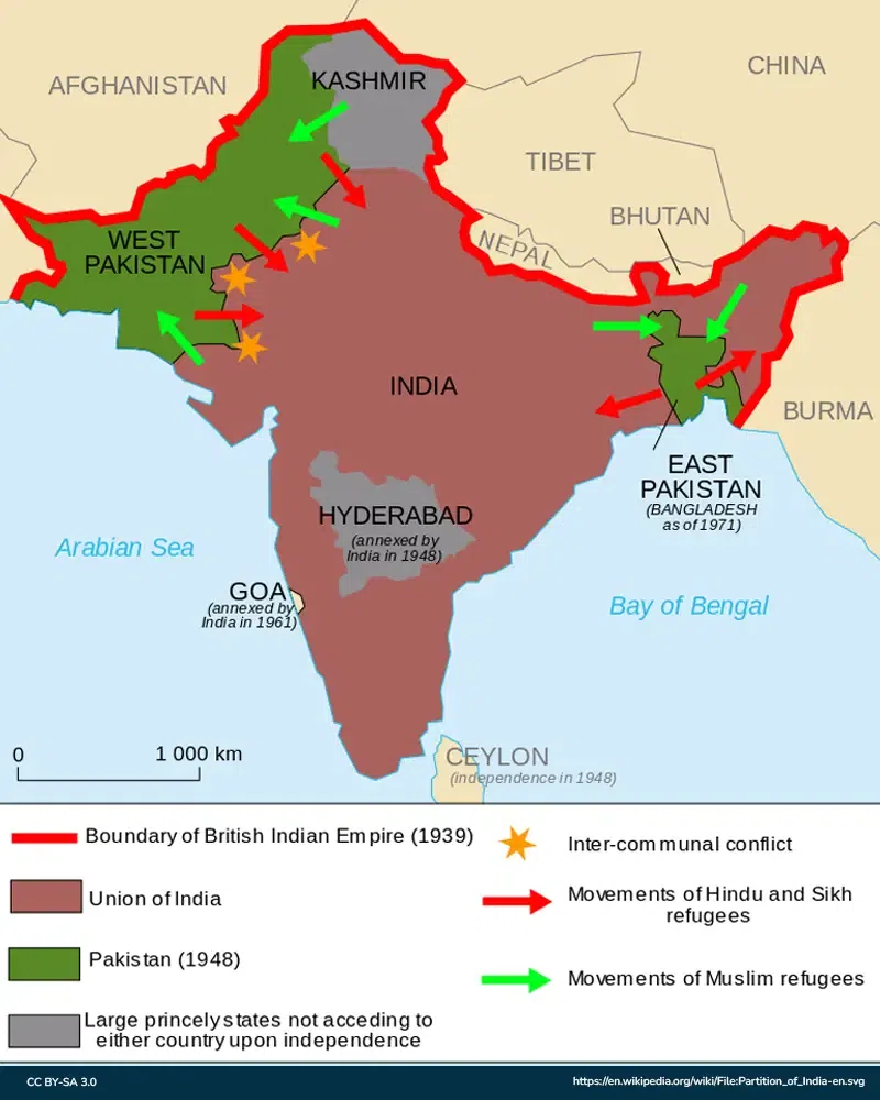
Radcliffe Line on Map
The following points describes How Radcliffe Line Looks on map:
- Western Terminus (Rann of Kutch, Gujarat):
- The Radcliffe Line starts in the western part of India, near the Rann of Kutch in the state of Gujarat. This region is marked by a distinctive landscape, including salt marshes and desert terrain.
- Northern Boundary (Jammu and Kashmir):
- Moving north, the line runs through the state of Jammu and Kashmir, with specific details in the Jammu region. The exact path might pass through various geographical features, and it contributes to the international border between India and Pakistan in this region.
- Punjab Region:
- The Radcliffe Line is most notable for its course through the Punjab region, where it separates the Indian state of Punjab from the Pakistani province of Punjab. This area holds historical significance due to its association with the partition of British India in 1947.
- Eastern Terminus (Bengal Region):
- Continuing eastward, the line extends into the Bengal region, where it plays a crucial role in delineating the border between India and Bangladesh. This eastern termination marks the conclusion of the Radcliffe Line.
- Landmarks:
- While the Radcliffe Line itself might not have prominent physical markers on the ground, the border regions often include border posts, checkpoints, and fencing. These may serve as practical landmarks along the route.
Conclusion on Radcliffe Line
Two nations were divided with Partition, but what actually divided the two nations into three countries today is the Radcliffe line drawn by the British lawyer, Sir Cyril Radcliffe. The line was drawn on August 17, 1947. On the eastern side, the line divided present day India and Bangladesh and on the western side, it divided India and Bangladesh. There were various factors that were taken into consideration before drawing of the physical line, such as irrigation patterns, maps, census reports, roads, etc. What led after the line was drawn was partition, migration, violence and most importantly birth of three new independent countries.
FAQs on Radcliffe Line
What is the length of Radcliffe Line?
Radcliffe Line between India and Pakistan spreads up to 3,323 km (2,065 mi), separating the Punjab region Thar Desert and the Rann of Kutch.
Who decided the border of India and Pakistan?
The boundary line is named after the British lawyer ,Sir Cyril Radcliffe, the man who was the given the responsibility of drawing the lines of Partition.
When was the Radcliffe line drawn?
The Radcliffe Line was drawn on August 17, 1947.
Where was the Radcliffe line drawn?
The Radcliffe Line is spread through the Rann of Kutch in Gujarat to the international border at Jammu in Jammu and Kashmir, dividing India and Pakistan into two separate countries.
How long did it take for Radcliffe to come up with the partition line?
Radcliffe was given 5-6 weeks to draw the line between two provinces.
What led after the Radcliffe line was drawn?
Portion of India and Pakistan and mass migration leading to communal violence were two of the major consequences of the Radcliffe line.
Share your thoughts in the comments
Please Login to comment...