Himalayan Drainage Patterns|Class 11 Geography Notes
Last Updated :
01 May, 2024
Class 11 Geography Himalayan Drainage Patterns: Class 11 Geography Himalayan Drainage Patterns notes are helpful for CBSE Class 11 students. They explain about the rivers that start from the Himalayan mountains. These notes talk about different types of rivers and how they flow. In this article, we also discuss important rivers like the Ganga, Yamuna, and Brahmaputra, and how they affect the land around them. These notes are easy to understand and are useful for students learning Geography.
The Himalayan Drainage Patterns notes cover all the necessary topics that are extremely important for the examination 2024. It can save you time and will positively affect your results.
Himalayan Drainage Patterns|Class 11 Geography Notes
Himalayan Drainage Patterns
In the Himalayan region, there are big rivers like the Indus, Ganga, and Brahmaputra. They start from the snow and ice in the mountains. As they flow, they make smaller rivers join them. This makes a network of rivers. The way these rivers flow and join each other makes different shapes. Some look like tree branches, some like straight lines with smaller lines across, and others like lines going out from the middle. These shapes are important for how the land looks and how people live there.
Evolution of the Himalayan Drainage System
Once, a powerful river named Shiwalik or Indo-Brahma flowed all along the length of the Himalayas, from Assam to Punjab, and then to Sind, emptying into the Gulf of Sind near lower Punjab. This happened around a million years ago, during the Miocene period. The Shiwalik river left behind a trail of evidence, including its continuous presence and deposits of sand, silt, clay, boulders, and conglomerates.
These deposits suggest that it originated from lakes and alluvial formations. However, as time passed, the Himalayan rivers underwent significant changes. They split into three major systems. This separation might have been caused by the upheaval during the Pleistocene era in the western Himalayas.
The uplift of the Potwar Plateau, also known as the Delhi Ridge, played a crucial role by acting as a barrier between the Indus and Ganga drainage systems. Similarly, during the mid-Pleistocene period, the sinking of the Malda gap, situated between the Rajmahal hills and the Meghalaya plateau, redirected the Ganga and Brahmaputra systems towards the Bay of Bengal.
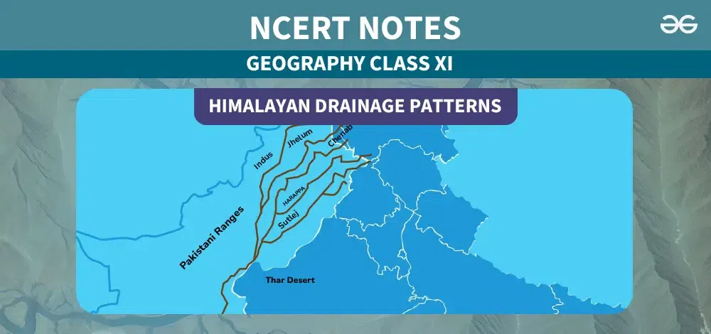
The Indus River System
- The Indus River originates near Lake Manasarovar in Tibet, fed by the glaciers of the Kailas ranges.
- Upon entering India, it flows in a northwest direction, passing between the Ladakh and Zanskar ranges.
- The river receives water from five eastern tributaries collectively known as Panjnand or Panchnad.
- Right-bank tributaries of the Indus include the Shyok, Gilgit, Hunza, Nubra, Kabul, Khurram, Tochi, Gomal, Sangar, and Kunar rivers.
- Left-bank tributaries comprise the Zaskar river.
- Near Mithankot, the Panjnad river, formed by the confluence of the Satluj, Beas, Ravi, Chenab, and Jhelum rivers, joins the Indus.
JHELUM
- The Jhelum, a significant tributary of the Indus, begins from a spring at Verinag, located at the base of the Pir Panjal range.
- It flows through Srinagar and the Wular Lake before crossing into Pakistan.
- Jhelum meets the Chenab near Jhang in Pakistan.
CHENAB
- Formed by the two streams – the Chandra and Bhaga streams, the Chenab is the largest tributary of the Indus.
- Also referred to as Chandrabhaga, it traverses approximately 1,180 km before entering Pakistan.
RAVI
- Originating from the Rohtang Pass in the Kullu hills of Himachal Pradesh, the Ravi is another significant tributary of the Indus.
- It flows through the Chamba valley in Himachal Pradesh.
SATLUJ
- The Satluj, also known as Langchen Khambab in Tibet, originates from the Beas Kund near the Rohtang Pass at an elevation of 4,000 m.
- After entering the Punjab plains, it meets the Beas near Harike.
- Originating from the Rakas lake near Mansarovar in Tibet, Satluj passes through the Shipki La on the Himalayan ranges before entering the Punjab plains.
- It is the river that supplies water to the canal system of the Bhakra Nangal project.
The Ganga
- The Ganga originates from the Gangotri glacier near Gaumukh in Uttarakhand, initially known as the Bhagirathi.
- At Devprayag, it merges with the Alaknanda River to form the Ganga.
- The Alaknanda originates from the Satopanth glacier above Badrinath.
- The concept of Panch Prayag – Vishnuprayag, Nandprayag, Karnaprayag, Rudraprayag, and Devprayag.
- The Ganga traverses a total length of 2,525 km in India, passing through Uttarakhand, Uttar Pradesh, Bihar, and West Bengal.
- It is the largest river system in India, with the Son being a major right bank tributary and the Ramganga, Gomati, Ghaghara, Gandak, Kosi, and Mahananda as major left bank tributaries.
The Yamuna
- Originating from the Yamunotri glacier, the Yamuna is the longest tributary of the Ganga, joining it at Allahabad.
- Right bank tributaries include the Chambal, Sind, Betwa, and Ken, while the Hindan, Rind, Sengar, and Varuna are left bank tributaries.
- The Chambal rises near Mhow in Madhya Pradesh and is renowned for its badland topography.
Drainage System
- The Gandak, originating from the Nepal Himalayas, joins the Ganga near Patna.
- The Ghagra, originating from the Mapchachungo glaciers, merges with the Ganga at Chhapra.
- The Kosi, known as the Arun in Tibet, originates from Mount Everest and converges with the Ganga.
- The Damodar drains the eastern margins of the Chota Nagpur plateau and eventually joins the Hugli.
- The Sarda or Saryu River, originating from the Milam glacier, merges with the Ghaghara.
- The Mahananda, originating from the Darjeeling hills, is the last left bank tributary of the Ganga.
- The Son, originating from the Amarkantak plateau, is a significant south bank tributary, joining the Ganga at Arrah, Bihar.
Yamuna River System
- The Yamuna River, the largest tributary of the Ganga, originates from the Yamunotri glacier at the Bandarpoonch peak in Uttarakhand.
- Key tributaries include the Sin, Hindon, Betwa, Ken, and Chambal rivers.
- The Tons River is its largest tributary.
- Its catchment area spans Delhi, Himachal Pradesh, Uttar Pradesh, Haryana, Rajasthan, and Madhya Pradesh.
The Brahmaputra
- Originating from the Chemayungdung glacier of the Kailash range near Mansarovar, Tibet, the Brahmaputra is known as the Tsangpo in Tibet, meaning ‘the purifier.’
- The Rango Tsangpo is its major right bank tributary in Tibet.
- It enters India near the west of Sadiya town in Arunachal Pradesh.
- Key left bank tributaries include the Lohit, Dibang or Sikang, Burhi Dihing, and Dhansari rivers.
- Major right bank tributaries are the Subansiri, Kameng, Manas, and Sankosh rivers.
- The Tista river joins the Brahmaputra on its right bank in Bangladesh, after which the river is known as the Jamuna.
Conclusion
The Himalayan drainage patterns show how water flows through the mountains. Important rivers like the Ganga, Brahmaputra, and Indus start from here. They have many small rivers joining them along the way. These rivers are vital for people living nearby, providing water for drinking, farming, and electricity. Understanding these patterns helps us take care of our environment and use water wisely.
Related Links
Himalayan Drainage Patterns- FAQs
What are Himalayan drainage patterns?
Himalayan drainage patterns refer to the flow of water through the Himalayan mountain range and its surrounding regions.
What are the major rivers in the Himalayan drainage system?
The major rivers in the Himalayan drainage system include the Ganga, Brahmaputra, and Indus, along with their numerous tributaries.
Where do these rivers originate?
These rivers originate from glaciers, lakes, and springs located in the Himalayan mountain range.
What is the significance of the Himalayan drainage system?
The Himalayan drainage system plays a crucial role in providing water for drinking, agriculture, and hydropower generation to millions of people in the Indian subcontinent.
How do the Himalayan rivers contribute to the economy?
The rivers support agriculture, transportation, and hydroelectric power generation, contributing significantly to the economy of the regions through which they flow.
Share your thoughts in the comments
Please Login to comment...