Uses of Polygons in Daily Life
Last Updated :
02 Apr, 2024
Uses of Polygons: Polygons is made up of two words “Poly” and “gon”. Poly means many and gon means side, thus polygon many means geometic object with many sides. It is generally used to mention pentagon or higher geometric shapes.
In this article, we will study what are polygons and how are they useful in our daily lives, and other in detail.
What are Polygons?
A polygon can be defined as a 2-dimensional closed figure made up of straight line segments. The minimum line segments must be three and can be more than three as well.

These line segments that make up the polygon are called edges of the polygon and the point where two edges meet is called vertex of the polygon.
Types Of Polygon
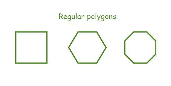
Regular Polygon: If all sides of the polygon are of equal length and all interior angles are of the same measure then the resulting polygon is a regular polygon for example a square, or an equilateral triangle are regular polygons.
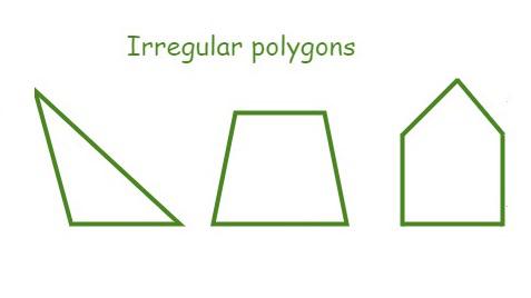
Irregular Polygon: If all sides of the polygon are unequal in length and at least one interior angle is of different measure then the resulting polygon is an irregular polygon for example a rectangle, or a scalene triangle.
Applications of Polygons
There are various applications of polygons in our day-to-day life. Real life applications of polygons includes:
- Architectural Design
- Floor Planning
- Facade Design
- Urban Planning and Land Use
- Zoning Regulations
- Land Parcel Mapping
- Geographic Analysis
- Natural Resource Management
- Automation of Vehicles
- Path Planning, etc.
Architectural Design
Designing Architectural structures and monuments is extremely important for engineers. If we carefully observe, almost every architecture is a product of geometric analysis done with precision and accuracy. Due to the properties of polygons, polygons are often seen to be used widely for designing architectures. This is mainly because polygons can be used to visualize the final output of the considered design and it helps to estimate the approximate spatial layout or space needed for the design.
Floor Planning
Civil engineers and Architects use polygonal figures to estimate the designs of floors in various rooms and corridors. Not only are these polygonal shapes used for creating exquisite designs of the floor but they are also used to estimate the amount of space that will be needed for the design. By effectively measuring the dimensions of tiles and available space, one can effectively calculate the total tiles needed for the floor.
Facade Design
Facade designs are a very important part of any building since it is the front facing of the building. Think yourself will you enter a building that has a bad facade or the one with an enthralling facade. By using polygonal shapes in facade Design, one can create different creative motifs that can appeal the general public. There are different buildings that use this idea and one of them is
Guggenheim Museum in Bilbao is one of the popular demonstrations of facade design that carefully incorporates polygonal shapes to create an exceptional design.
Urban Planning and Land Use
Planning of urban areas has always been a topic of great importance. Due to the limited availability of resources in urban areas, it is necessary to find methods to strategically plan these resources’ use. Polygons have the required shapes and designs that can be useful for urban Planning.
Zoning Regulations and Land Mapping are two of the most important uses of polygons in Planning.
Zoning Regulations
Every area consists of different regions with different available resources and populations. This region needs to be divided into zones, these zones resemble a polygon in terms of the boundaries created. Depending on different parameters like the resources, people, and Land in different areas boundaries are set. These boundaries are made with the help of polygonal figures which help to define precise outlines. This is how polygons can be used for zoning a big city depending on certain factors.
Land Parcel Mapping
Dealing with large cities is often a complex task, therefore. dividing cities into small Land Parcels is an ideal solution for any planner. This task of creating Land parcels out of a large place is done by urban planners with the help of polygons. Each Parcel is independent and can be small or large as compared to any other Parcel. It is important to note that polygons are used for this division of land based on factors like size, shape, and requirements. This is how efficiently the Planning of each Parcel can be done.
Geographic Analysis
The nature around us is a perfect example of geometric shapes. The hills are like triangular polygons at different elevations, the farms are like rectangular polygons arranged together. Therefore we can use polygons to analyze and generate some Geographic Information to effectively utilize them.
Natural Resource Management
An understanding of different types of resources is necessary to ensure the proper distribution of resources. Certain regions are rich in one kind of resource while others lack these resources. Polygons are important figures that are used in GIS for studying plantations at different places, monitoring populations, and managing natural resources.
Automation of Vehicles
With the advancement in technology, developers are trying to automate the vehicles used for traveling purposes. Various needs must be considered while designing these autonomous vehicles to avoid any mishaps. Polygons are used in designing such vehicles where they are trained to react accordingly when they encounter any polygonal shape.
Path Planning
Any road or highway can be considered a collection of different polygons. Even the crossroads and lanes are a combination of polygonal shapes that can be used for planning a path by the vehicle.
By using various graph traversal methods and other algorithms, vehicles can be incorporated with AI that generates accurate routes to be followed based on the destination. This route generated will be a combination of connected polygons that will define the path.
FAQs on Uses of Polygons
What are polygons?
A polygon is any bounded shape that is made up of line segments. The term poly is used to signify ‘many’ i.e. a polygon is made up of many line segments.
Why are polygons useful?
Polygons are useful in various cases, i.e. in graphic designing, in 3-D modeling, pattern designing, etc.
What are the uses of the polygon in GIS?
GIS is a technology that uses AI to give insights into Earth’s geometry. Polygons are used in GIS to store the database of mountains, hills, rivers, and lands in the form of polygons and then provide Information about them
How are polygons used in making zones or in zone Mapping?
Polygons can be used to define the boundaries of different regions and depending on the boundaries the regions are categorized as industrial zones, etc.
What are applications of polygons?
Some applications of polygons in day-to-day life include the use of polygons to create logos for companies and to develop typography and origami. It can also be used in die-cutting
Share your thoughts in the comments
Please Login to comment...