Project Idea | Real Time Vehicle Tracking
Last Updated :
10 Aug, 2018
Project Title: Real Time Vehicle Tracking
Introduction: This project aims to solve the problem of tracking and accountability of vehicles by providing a software platform. This project would serve as an important step to help in Vehicle tracking, component monitoring, vehicle analysis and fleet management. An efficient vehicle tracking system is implemented for monitoring of any equipped vehicle from any location at any time with the help of Global Positioning System (GPS) and Arduino Board which will enable users to locate their vehicles with ease and in a convenient manner. This web application will provide a dashboard for better and easy understanding of their vehicle positions and related statistics.
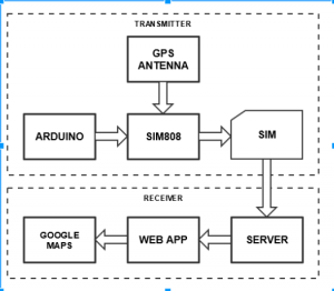
The core function of our project is to develop a tracking system that is cost-effective so we have made use of the following components that have effective operation and usage. In this section, the hardware part, i.e. hardware components used for the project are discussed in details. The heart of the project that is, as microcontroller we used Arduino Uno. Initially, we worked on getting geo coordinates i.e. latitude and longitude and for this, we made use of the GPS module to capture location, speed and time of last received data in accordance. Then using GSM technology, the captured data already sent to the web server is stored and for this, we have used SIM808 module.
Conceptual framework:
Features Provided:
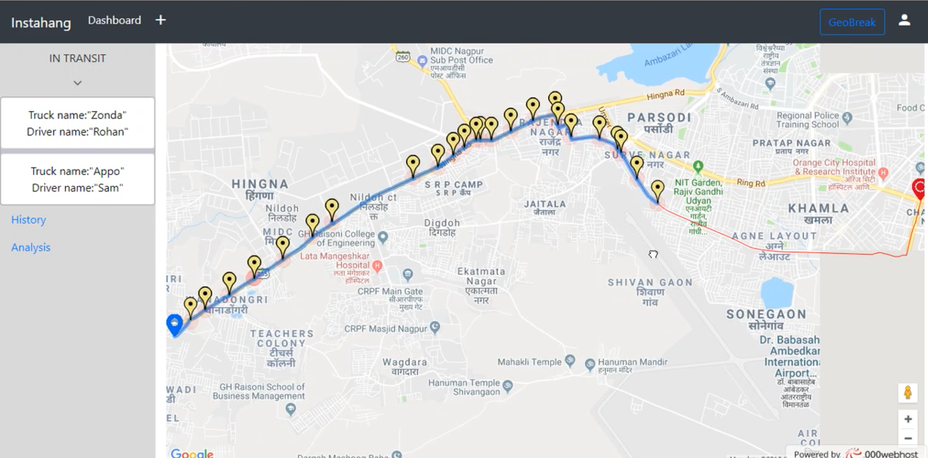
- Real-Time Tracking
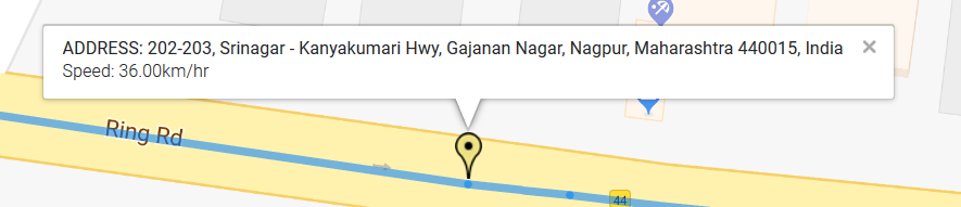
Here, the GPS receiver receives the location data like latitude and longitude of a vehicle and send them by using an HTTP request to web server. The browser is used to load the PHP web page which contains Google maps to show the location of the vehicle in real time. The web page containing the map directly marks the coordinates, as it arrives, without reloading the page. That means, in real time, we get to see the location of the vehicle.
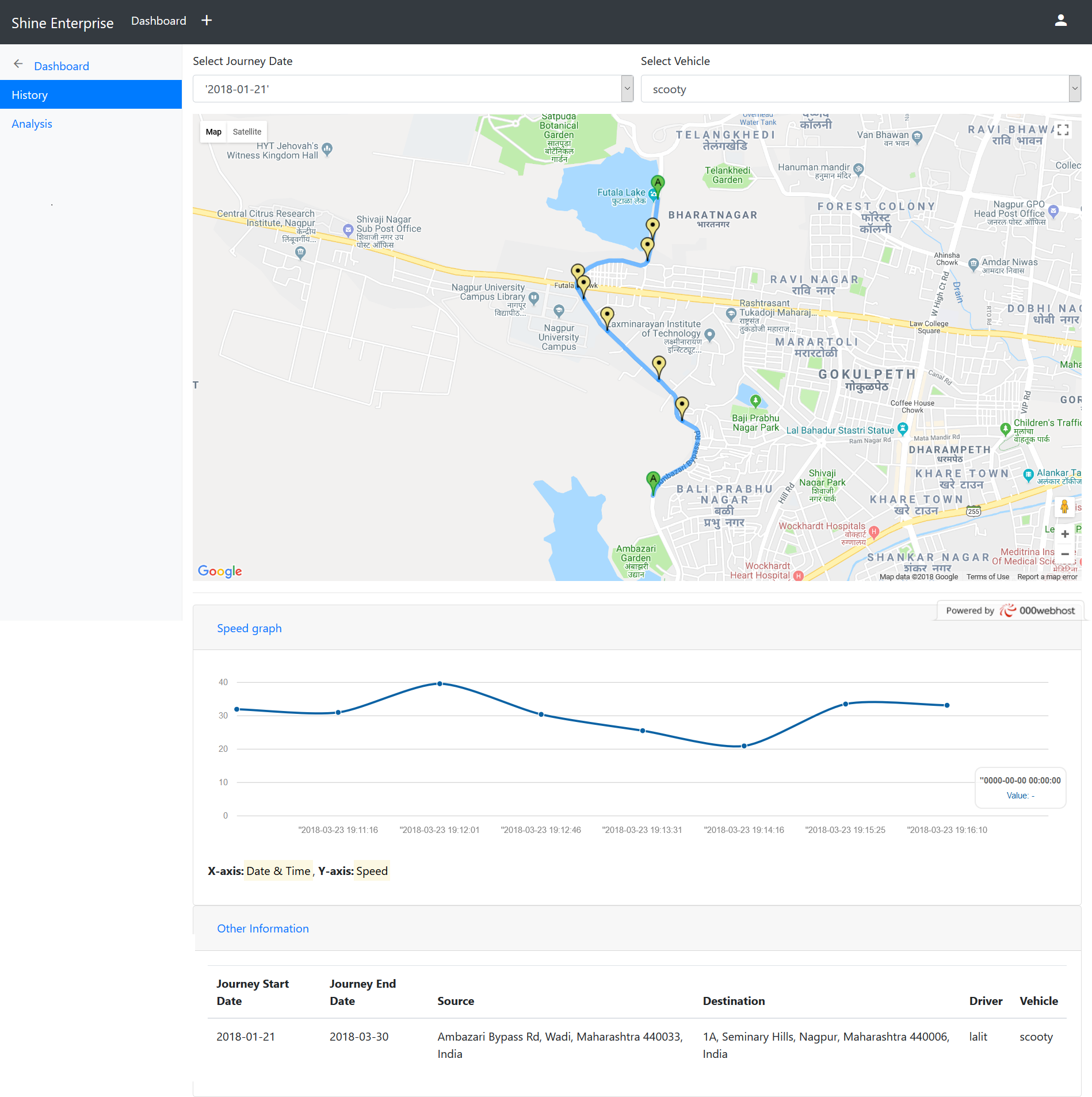
- History
In history, we ask the user to select the date of journey, the names of vehicles which were on a journey on that day are displayed by selecting the vehicle the journey of that vehicle on that date is fetch. The google map with a marker is displayed on the screen. Along with the map, Time-Speed Graph of journey and details of the journey is displayed.
In history, the user has to select date of journey and correspondingly the names of vehicles active on that day are displayed. After vehicle has been selected, corresponding journey details are displayed. Journey details include google maps representing journey, graph showing speed of vehicle at every instance of time and driver details consisting of driver details.
- Report Generation
This part includes generation of specific reports for drivers, trucks, and journeys. In this pdf report is generated, which are used by owners for analysis. For driver report, driver has to be selected which then generates a report showing basic details and journeys done by him. For truck report, truck has to be selected which then generates a report showing basic details and journeys done by him. For journey report, date and vehicle need to be selected which then generates a report showing basic journey details, google maps representing complete journey and graph showing speed of vehicle at every instance of time.
- Geofencing
Geofencing is one of the important features of our project. As the problem statement stated that driver may take a longer route to increase fuel consumption and ask for more money for his long journey or the driver unintentionally took the wrong path, such scenario affects the throughput of the journey. It also affects the performance of vehicle and driver. Thus, the geofencing is applied.
Geofencing is the virtual boundary to the optimized path from source to destination which is defined at the time of journey creation. It is a radius which user have to input in meters. Whenever vehicle deviates from its optimized path and the deviation is more than the defined radius then it means it’s a geofencing break, which results in a notification popup generated on the screen. This helps user to know that geofencing is broken by this vehicle.
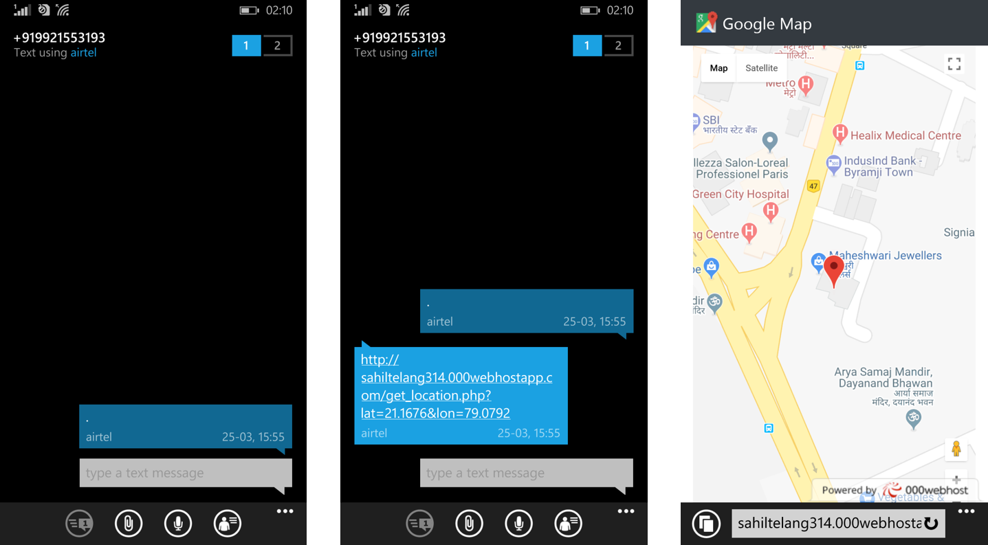
- SMS Module
SMS module is an important feature for the user. As the project is for vendor and they are very busy they can’t stay in front of computer and check the current location of vehicle. In this scenario, SMS module is useful to know the current location of vehicle. To know the current location of the vehicle user, have to send a SMS to a number of the sim attached to the hardware. In response, the SMS a link is generated when user clicks on that link on the browser it shows a google map with the marker. The marker is the current location of the vehicle at that time. Thus the SMS module helps the user to check the location of vehicle anytime he wants.
-
Agile Hardware
Hardware is reliable, low cost and compact. As we stated that this project has various application in various areas so for those applications hardware will be fixed only we have to change the web application and the method to use the functionality. The functionality and construct of this hardware is fixed and working for this.
Images:
Tools Used: Apache HTTP Server, MySQL database, GoogleMaps API.
Languages: C, PHP, Javascript, Ajax, Bootstrap, HTML, CSS
Hardware: Arduino UNO, SIM808, GPS antenna
Application:
This project can be deployed in various different fields like elderly and disabled care services, logistic division, emergency services and rescue operation, school bus tracking, and accounting.
- There exists an issue where there is some delay between fetching of actual vehicle location and it being displayed on the map. Also, the Google Maps API allows up to 23 markers for free.
- The developed system is of low cost, reliable and compact. The hardware modules used in the project are easily accessible.
Future Scope:
The project can be extended as a mobile application for IOS and Android and if the hardware module sizes are miniaturized it can track humans, equipment, and goods.
Project Link: http://sahiltelang314.000webhostapp.com
Demo Video: RTVT Video
Team Members:
- Tejas Kale
- Sahil Telang
- Utkarsh Shende
- Lalit Nikhare
Note: This project idea is contributed for ProGeek Cup 2.0- A project competition by GeeksforGeeks.
Like Article
Suggest improvement
Share your thoughts in the comments
Please Login to comment...