Indoor Navigation using WiFi
Last Updated :
26 Aug, 2021
Whether we travel in a mall, shopping complex or University campus all of us may take some time looking at the normal Maps coming to know closer understanding where we are or where we need to go, here comes in the role of indoor Maps.
Indoor navigation is a recent concept still having a lot of scope for research. We travel indoors by using indoor positioning systems (IPS). IPS is like a network of devices which helps us to wirelessly find out the location of various objects or people inside the buildings it completely relies on the nearby anchors or local tags which help us to provide the information regarding the environmental aspects that help us to find out the location of a particular device.
Ways of Determining Position Indoors:
Indoor positioning service can be provided both by using beacons and Wi-Fi. The use of Wi-Fi or beacons depends solely on the requirement. Beacons are basically preferred when we require very high accuracy but in huge university campus, beacons will not be a better option, for they have to be installed in proximity with each other making it’s usage impractical and uneconomical. The drawback of using Wi-Fi is that the accuracy of location will solely depend on signal strength which may suffer sometimes but with recent developments in Wi-Fi speed and SDKs like android 9 and 10 it is a problem that can be tackled easily.
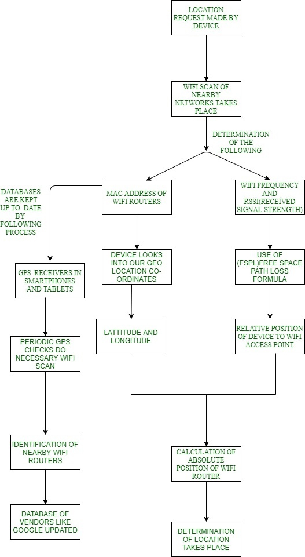
Process of Determining Users Position using Wi-Fi: When using WIFI our device requires the following information for calculation of distance.
- The latitude and longitude
- The relative position of our device to each Wi-Fi. It is calculated by making use of Wi-Fi frequency (usually 2.4GHZ) and signal strength as depicted in formula below.

This is modified free-space path loss formula where the frequency is in dBm and signal strength in megahertz. - The absolute position of a WIFI tower is also calculated using the above information (point 1 and 2). This information is then integrated into a code created in the Android studio.
The following flowchart explains the working of an indoor positioning system
Suitable SDKS (with their features) for Indoor Navigation are listed below:Oreo (Android 8):
- Geofencing: It helps in the creation of a virtual perimeter.
- Provision of Cache.
Enables the APP to:
- Run faster
- Consume less power and memory
- Provide a smooth in-app experience
Pie (Android 9):
- Provides us platform support for indoor positioning services.
- RTT (WIFI Round Trip Time) APIs to measure the distance to nearby WIFI access points ( usually 3).
- Its accuracy is between 1 to 2 meters.
- With this accuracy, we can make in-building navigation quite easy.
Android 10:
- Offers a high-quality multi-window support.
- Manages the way your app is displayed on foldable screens.
- Enables multi-tasking across apps and windows and provides screen continuity
- It eliminates the navigation bar area and allows a user to use full screen to deliver a more rich and immersive experience.
- More user control over location data.
- Prevention of device tracking.
- Blocking unwanted interruptions.
- Offers suitable support for display so that high quality videos can be provided by using limited bandwidth.
- Enables high performance and low latency modes.
- Provides high end-user experience in real-time gaming, navigation, and active voice calls.
- Reduces power consumption.
Like Article
Suggest improvement
Share your thoughts in the comments
Please Login to comment...